
Amelebrige to Elmbridge: The Biography of a Borough
Saxon Origins
It is a little known but important fact that the Borough’s history stretches back over a thousand years. Far from being ‘invented’ in 1974 with local government reorganisation, the story begins in smoke-filled Saxon times during the sixth or seventh century A.D.
The Saxon name for an administrative unit was a ‘hundred’. This referred to an area of land enclosing one hundred households, one hundred men who could bear arms, or one hundred hides – historians are still uncertain, but the former is most likely. One of these hundreds was called ‘Amelebrige’ and covered a strikingly similar area to modern Elmbridge. The only difference was that part of Thames Ditton and Claygate were in the Kingston hundred, not Amelebrige.
This ancient concept of the hundred gave The Elmbridge Hundred project its name. Rather neatly, the title also alludes to another important hundred - Elmbridge Museum’s centenary in 2009.
Domesday
Amelebrige was recorded in the Domesday Book of 1086 – the first historic mention of the Elmbridge area. William the Conqueror commissioned the Domesday Book to get to grips with his new kingdom. It was a survey of land, landowners and livestock in England, designed to help with taxation and defence. The holdings of each landowner were listed by manors, according to the hundred in which they were found.
Here is Amelebrige’s entry in the Domesday book, located just above the red letters:
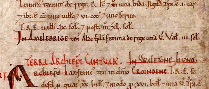
(Image courtesy of The National Archives, ref. E31/2/1 f30v detail)
Looking for Elmbridge's bridge
The name Amelebrige derives from the original name of the River Mole (‘Amele’) and the Old English word for a bridge (‘brige’). The Mole runs pretty much through the centre of Elmbridge, from north-east to south-west, cutting the Borough in two.
Local historians have enjoyed speculating where this elusive bridge over the River Mole may have been situated, and whether a settlement of some kind lay alongside. The Victoria History of Surrey (1911) claims that the bridge must have been located at the juncture where ‘the road from London to Chertsey crosses the Mole or Emlyn on its way west, and here probably the hundred court was held’. By process of elimination, eminent local historian Royston Pike posited that this place must have been on the lower slopes of Esher, at the bottom of what is now Lammas Lane. This would site the bridge where Albany Bridge now stands, just by the Princess Alice Hospice. Pike’s other reason for suggesting the site is that ‘Albany Bridge … is almost exactly in the middle of the Hundred, which would make it very convenient for access from all parts.’ The speculation is a logical one, but no conclusive proof has been forthcoming as yet - ‘the ‘sullen Mole’, as Milton calls it, keeps its secrets’ (Pike, The Elmbridge Story, 1977).
Nevertheless, what is certain is that the name ‘Elmbridge’ has nothing to do with elm trees. Pike writes in no uncertain terms that: ‘The inclusion in the new Borough’s armorial bearings of a lusty elm growing out of a two-arched bridge is just a piece of heraldic nonsense.’
Early Modern Elmbridge
Over time language changed and ‘Amele’ became ‘Emley’ or sometimes ‘Emlyn’. From at least the seventeenth century to the beginning of the twentieth, the hundred was generally known as ‘Emley Bridge’. Here it is shown on John Speed’s map of Surrey from 1610. Ignoring the early modern spellings (not yet standardised) the names of Emley Bridge’s towns and villages are almost identical to today: Waybridg, West Mowlsey, Esher, Cleagate and so on…
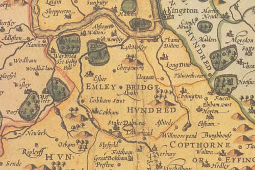
(Detail courtesy of The Surrey History Centre, 2010)
During this era, royal settlement vitalised the hundred. Henry VIII built Oatlands Palace in Weybridge, and from the 1530s onwards a succession of Tudor and Stuart monarchs passed through its gates (until Cromwell razed the place to the ground in 1650).
The presence of monarchy encouraged nobles and other hangers-on-royal-coattails to settle nearby. Huge estates began to spring up all over the Borough: William Wayneflete's palace in Esher, Ashley Park and the Manor House in Walton, Portmore Park in Weybridge and many others. Visit the biographies section on this site to find out who lived in these grand abodes.
A burgeoning Borough
Although there is a wealth of information about particular people and places, frustratingly few references are made to the Elmbridge region as a whole in the centuries after 1086. Other than the name, little can be learnt of the area’s composition and organisation.
However, with the advent of the census from 1801, figures reveal that the population of the hundred was shooting up. Across the nineteenth century the population went from 6,630 to 34,600, encouraged in no small part by the arrival of the railway in 1838. As John Easthope frantically bought up land to take his railway from London through Weybridge to Southampton, people flocked to Weybridge and other Elmbridge towns along the line. These brave new commuters seemed to confirm what Tudor and Stuart monarchs had discovered centuries before: that Elmbridge is a very desirable place to live.
Elmbridge Restored
At the beginning of the twentieth century, the local government map of Elmbridge was peppered with urban district councils: Esher and the Dittons, Molesey, Walton, and Weybridge. In 1933 the map was simplified when Esher was amalgamated with Molesey, Cobham and Stoke, and Walton joined with Weybridge.
Finally, the Local Government Act of 1972 enforced the union of Esher Urban District Council with Walton and Weybridge UDC. But what to call the new borough? The name had to be relevant to the whole area, and so partisan suggestions of ‘Albany’, ‘Claremont’ and ‘Walton’ were quickly ruled out. Royston Pike picks up the story:
‘Ideas were running out when someone recalled that there was a rural deanery of Emly, and another commented that there was a telephone exchange at Surbiton, which was called ‘Elmbridge’. This led to a run on the reference books, and it was discovered that they had all been living in Elmbridge without knowing it, while the fact that Elmbridge had a past of impenetrable obscurity might be seen as a positive advantage.’
With that, Elmbridge was reborn on 1st April 1974. Today the Borough covers 23,803 acres, offering contrasts of quiet countryside and hectic commuter-ville to over 124,000 residents. Contemporary Elmbridge is also renowned for its enthusiastic real-estate development and redevelopment. With this continual movement in mind, The Elmbridge Hundred sets out to preserve the memory of the Borough’s historic sites, and those figures associated with them, long after their physical remains may have disappeared.
(Crown Copyright. All Rights Reserved Elmbridge Borough Council LA 100024882 2010)
Sources
- Elmbridge Museum archive material
- The National Archives website: http://www.nationalarchives.gov.uk/domesday/
- Royston Pike, Monograph No 3: The Elmbridge Story, 1977
- Surrey History Centre archive material
- The Victoria History the Counties of England: A History of Surrey, Vol III, 1977